Decision Intelligence From Space

We help organizations build and optimize decision making systems using Earth Observation Satellite Data.

We Work at Scale

Our products and solutions are build to deliver information and insights at any scale. A farm field insight or actionable input at regional and country level, we have it delivered.

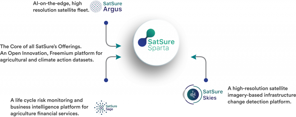
A Diverse Product Suite

SatSure works at the sustainability nexus of agriculture, infrastructure and climate change. Our diversity in product offerings reflects the inclusive approach we have towards enabling decision making for our clients, from top till the last mile.

Bringing Remote Sensing Data to Organisations

Amid the pandemic, the business ecosystem realized the potential of utilizing satellite data for businesses across sectors such as agriculture, health, finance among others. Along with the new space tech norms announced by the central government, the demand for such data increased over the last few years.

SatSure Sparta is an Open Innovation Platform launched by SatSure on the advent of 2021. It was launched, bringing ready to analyze remote sensing data to people and organizations lacking the necessary infrastructure and human resources.

The platform in the initial milestones is envisioned to assist in the following:

  1. Access to basic agricultural information for administrative and farm levels through APIs

  2. Executed and suggestive use cases for the agricultural value chain

  3. The option of uploading problem statements (Both functional and technical problems)

  4. A platform for people to join and collaborate to solve a problem statement
  5. Ability to upload solutions and solve use cases

  6. Solutions open for the community to access

As a first step towards this effort, the platform boasts multi-modal, multi-data access to datasets for the agricultural and climate tech ecosystem.

Accessing data on SatSure Sparta

The platform runs on a freemium model. Most of the datasets are open to access, while specific proprietary datasets are made available at very affordable costs. While in the collaboration model for Proof of Concept (POC), SatSure Sparta also opens paid datasets in certain use cases. This idea is to encourage PoCs and prototype building within the ecosystem. Once the PoCs are validated and understood well, the scalability of the solutions/ products becomes more effortless, thus contributing to optimizing resource utilization.

  •  SatSure Sparta addresses the Quality, Accuracy, and Sufficiency of Data Sets for Agri Infrastructure in developing & underdeveloped countries through a robust scientific approach to spatial data insights.
  • The platform provides opportunities for collaborative Innovation: In India alone, 400+ AgTech startups and others like lenders, insurers, academicians, researchers, policymakers, traders are in the value chain.
  • It provides opportunities to utilize a shared pool of Inter and Intra domain experts. The platform is developed with expertise from different sectors to solve a genuine local or global problem.
  • It is a good space application that provides access to quality data and a Platform for Co-innovation.

Contributing to SDGs

SatSure Sparta contributes, directly or indirectly, to the number of Sustainable Development Goals (SDGs). The users on SatSure Sparta come from a multitude of backgrounds. SatSure Sparta today boasts more than 300+ active registered users on the platform coming from government, private, academic, and non-academic backgrounds.

The platform has an enterprise version for Re/Insurance clients helping them better underwrite and resolve claims, improving financial inclusion of the under-served farmers.

Our APIs have been delivered for multiple climate-resilient agriculture projects and adopting sustainable agriculture practices in biodiverse zones.

Currently, we are forging multiple partnerships with IoT companies to help scale IoT solutions, enabling the delivery of agricultural advisories by optimizing resources. This engagement is a two-way engagement as it also allows us to collect ground data and in-situ measurements to retrain and incrementally improve our accuracy levels, especially across horticulture crops.

Our next target is the carbon credits domain. We are currently discussing with multiple stakeholders to conceptualize and implement satellite remote sensing data for carbon credit lifecycle management and monitoring.

We are also trying to take geospatial data to sectors that have very little penetration of such data like FMCG etc. The alternate data can add value additions and help build newer solutions to the existing problems in these sectors.

SatSure Sparta is our step towards collaborative efforts for a better, sustainable future.

Analysis of Simlipal Fire

Forest fires, natural or man-made, inflict almost irreversible damage to the environment, forest and the inhabitants. In India, Simlipal in Odhisha has been prone to fires and has unfortunately seen many such incidents.

The potential of using satellite data and imagery in analysing and studying such incidents is no news. Using such data can be helpful in locating the concentration of fire spots and taking measures accordingly to stop the spread. 

Simlipal is a tiger reserve and a biodiverse zone in the Mayurbhanj district in Odisha. Last year in February, forest fires broke out in the region. According to media reports, the fire was brought under control after almost a week. However, fortunately, no loss of life or injury to lives were reported.

At SatSure, the team was initially working on a project to study landscape assessment with the client. However, as the fire broke out, the team additionally shifted its focus to using satellite data for analysing the fire points in the region and how it was spreading in the region.

Fire Spot Analysis

SatSure team monitored the forest fires to give an understanding of how the forest fires were progressing and fire intensity to the client. The team conducted a 10-day analysis to capture the movement of the fire points across a certain date set.

Using satellite imagery, it was possible to identify the active fire spots, i.e. spots with very high temperatures revealing the possibility of a fire in the spot.

Satellite data also allows us to identify the high and low vulnerable areas prone to forest fires and develop a forest hazard map. After overlaying the forest hazard map on the active fire points, the team 68 per cent of the active fire points fell within the high (in red) and medium (in yellow) fire risk regions.

This analysis reveals the potential of using satellite data for studying climate and natural hazards. Such technologies can also be deployed to monitor slash and burn agricultural practices.

We as a country are working to build a stronger nation. One of the main pillars for achieving this goal is building a strong and reliable infrastructure. As we move towards developing our cities and digitally connected smart cities, proper planning and monitoring of the infrastructure, becomes the need of the hour.

Building infrastructures are The potential of high-resolution imagery-based analytics in monitoring infrastructure and property changes are very high.

Data for Building Infrastructure

Satsure is looking to provide a solution to this problem through its SatSure SKIES which is a high-resolution satellite image-based infrastructure change detection platform.

The product delivers end-to-end solutions to multiple sectors like banking, insurance, utility, aviation, and disaster management among others. Not only satellite imagery, but SatSure also offers insights from multiple sources to ensure the data is made available from all aspects and not restrict it to what is visible from the satellites. 

Insights provided by SatSure can help in three main functions:

  1. Planning;
  2. Monitoring; and
  3. Maintainence.

The data can help the client businesses make calculated decisions and assess the risks involved in certain projects.

The images provided gives a glimpse into how change detection is done for infrastructure projects through highlights in red circle. Accordingly, the  changes are also visible in the RGB image. This is currently used for monitoring the construction progress and taking decisions. 

Using SatSure Skies, businesses will not only be able to identify the risks before starting the project but also find the damages or risks that might come up while building the same. 

People closely aware of the credit industry are bound to know about Bureau scores. It is used to measure an individual’s creditworthiness. Individuals can take loans from financial institutions by sharing proof of their incomes, CIBIL scores among others to help the bank to understand if they will be able to pay back the loan on time and assess the risk in issuing loans to them.

But what happens when farmers take loans for their agricultural needs? How can the banks assess the risk of the farm and confirm if the yield will be good enough for the loans to be paid back?

SatSure aims at solving this issue through SatScore, a farm risk score, which helps evaluate the underlying risk of the farmland, the most important asset in agriculture.

Several farmers take loans for meeting their agricultural needs. While some reach out to the local lenders and some reach out to banks.  Today, the banks do not possess the local knowledge about the farmland, its inputs and outputs as opposed to maybe the local money lenders. While local money lenders might even personally know the farmers and understand the risk of lending them, banks might not have access to the local knowledge.

It is also important for the financial institutions to have an understanding of the farmland to ensure that a good yield gets produced. With good yield potential, it might become easier to identify the farmers who will be able to pay back the loan on time.

Accessing Farm Risk

SatScore is a single score allotted for particular farmland, indicating how good or bad the farm is.

Using this platform, financial institutions will be able to track the performance of the farmlands. It will help them assess which land has a better chance of good yield thereby helping them in issuing loans.

SatScore is aimed at enabling visibility on what is happening at the farm so that banks know the cropping history of the land and understand the risk level while giving loans. The increased visibility will help enable institutional financing of agriculture through organised finance lending organisations.

Today, the assessment of the farmlands are quite difficult. It requires banks to have people on the field who would be familiar with the geography of the region and local systems.

SatSure is looking to help here by assessing the farm and thereby helping the banks make informed decisions.       

https://sparta.satsure.co/#/index/cygnus

Satellite data offers important insights across sectors such as agriculture and crop monitoring. However, optical satellite data come with a few challenges.

During monsoon season, heavy cloud cover affects optical satellite data, which can lead to limited data availability. SatSure is looking to solve this problem with its SatSure Cygnus, an all-weather, rapid revisit virtual constellation,  which can provide insights about crop conditions even during such heavy cloud cover situations.

Providing Clear Data in Heavy Cloud Cover Situations

SatSure Cygnus is an optical virtual constellation capable of delivering high-frequency revisit (up to 3 days), high resolution (now up to 5m, will further improve to 1m), weather agnostic optical satellite data in five bands, namely, Red, Green, Blue, Near Infra-Red, Short Wave Infra-Red.

It will help in:

Insights provided by SatSure can help in three main functions:

  1. i) Solving the cloud cover issue encountered in optical imagery by using Synthetic Aperture Radar data
  2.  Solving the procurement of high resolution and high frequency revisit data without the need to deploy physical satellites.

It processes data from SAR (Sentinel-1), NIR and RGB (Sentinel-2) which can be used for several applications in vegetation monitoring including Crop modelling, crop growth stage & crop identification, yield estimations among others.

Agriculture is one of the most important sectors in India and it is only right to focus on solving all the related issues in the segment. One such important aspect of culture which demands our attention is Soil moisture.

Soil moisture is the infinitesimal fraction of the Earth’s water present in the top 2 inches of the soil and forms a crucial part of the global water cycle. Studying the soil moisture will be beneficial in optimising irrigation water, crop yield prediction, water budgeting, predicting agricultural drought.

SatSure is looking to provide answers regarding this through its Soil Moisture product. It is capable of delivering daily volumetric soil moisture data at 20m resolution.

Key Highlights

Most of the existing soil moisture products in the market are available at Kilometer level resolution. SatSure’s product delivers data at 20m resolution making it much more suited for precision agriculture, and irrigation scheduling among others.

SatSure Soil Moisture product uses:

  • Sentinel-1 IW mode
  • Landsat-8 Operational Land Images (OLI)
  • Sentinel-2 images for estimating Soil Moisture Content (SMC).

It will help clients monitor the variations and make necessary changes in cropping patterns or agricultural inputs way before any damage occurs. Apart from this, the availability of the data will not be affected by the presence of clouds or bad weather.

Areca-nut or commonly known as betel nut is a commercial fruit in South East Asia. According to a report by Allied Market Research, by-product tannin obtained by processing immature areca-nuts use also used for dyeing in food colour, tanning leather, clothes among others

In a unique project project, SatSure is using geospatial technology integrated with IoT sensors to map and monitor Areca-nut plantations. The online dashboard helps monitor and visualise all the products such as weather data including rainfall, temperature, solar radiation etc, LULC, Areca-nut plantations. It will also help in forecasting rainfall, relative humidity, and temperature among others at least five days before.

In the image, you can see Pradeep Bisen, Technical Director of Geospatial at SatSure setting up the IoT sensors along with our partners.

Monitoring Areca-nut Plantations

SatSure is mapping Areca-nut plantations, for precision farming, by monitoring its growth with time-series satellite data and health status as part of this project. The team is also studying weather data to forecast rainfall, temperature and weather conditions to be used for near or before real-time advisories.

The accurate status of the area of the Areca-nut plantations, LULC (Land Use Land Cover) area, monitoring the health status and crop growth with weather forecasting to help farmers in the application of insecticides, pesticides, recovery of farm loans, watering for plantations or water management, estimating the market price for the areca nuts.

SatSure is also working towards generating a site suitability map for Areca-nut plantations using different datasets such as soil PH, soil types, soil texture, soil depth, soil moisture, temperature, rainfall among others. This will help farmers to decide on the right areas for the plantations which will lead to high crop yield and low maintenance costs.

SatSure Skies delivers an Airport Information Management System for aviation sector.

Today, Aeronautical Information Services (AIS) support flight operations by providing static information publications such as Aeronautical Information Publication (AIP).
The traditional AIS products are designed to be functional with manual interventions and consumption.

Over a period, with digitisation and technology improvements to handle large datasets coming at high frequencies and from multiple sources, building a complete digital information management system has become possible.

Thus, the transformation of AIS to AIM is the transition of aeronautical information from traditional charts and physical publications to real time standards based aeronautical information.

Natural disasters such as heavy rain, cyclones, floods among others might inflict serious damage to nature and lives. One of the major issues involves damage of crops and agriculture. Severe damage to agriculture can even lead to scarcity in the availability of food. 

Over the last few years, Eastern India has seen recurring events of cyclones and floods. In September last year, a few districts in Cuttack experienced floods. SatSure used satellite imagery to analyse the crop damage.

Crop-damage analysis

SatSure had crop classification data using optical data from Sentinel-2, of the region which allowed the team to identify the specific crops grown in different areas. Using satellite images, the team studied pre and post-event analysis.

Optical data which is multispectral in nature helps us not only understand the crop classifications but also monitor the crop growth stages throughout the cropping phenology.

As monsoons can have heavy cloud cover, SAR data from Sentinel-1  was used to identify the inundated areas which were overlaid over the crop classification data. This allowed the team to learn more about the areas where crops got damaged.

As we studied the crop growth, any damage to the crops results in anomalies in the data helping the team identify the problem. When the flood inundation data is matched with the crop data, helping identify the damage specifically due to floods.

The SAR data along with Digital Elevation Model (DEM) helps capture the:

  1. Extent of flooding,
  2. Initial depth of flooding, and
  3. Frequency of flooding. 

Through this study, SatSure could demonstrate the fusion of both the imageries to get the required data for solving agricultural problems.

Last year in October, several reports surfaced revealing that a huge number of fish died and were floating the Kameng river in Arunachal Pradesh. It was reported that the water turned black and muddy mainly due to a high level of turbidity.

SatSure could analyse the situation and locate an avalanche slide that had occurred near the Kameng river.

Capturing Avalanche

During the initial request by the client, SatSure was given just one piece of information - A slide occurred somewhere in Arunachal Pradesh. After researching and collecting data from multiple data sources, the team came to learn about the river turbidity Kameng river due to which a large number of fish died.

However, the challenge was that the optical data set could not be used for the analysis due to the heavy cloud cover. SatSure conducted the analysis using SAR (Synthetic Aperture Radar) data and studied the before and after data of the location to understand the change that had happened because of the avalanche.

In remote sensing, generally, two main types of data are used- optical and radar. Optical data includes visible wavebands and thus can produce images close to almost what human eyes can see back at Earth. Meanwhile, radar data does not offer zoomed images like optical data. However, radar data remains unaffected by weather conditions, unlike optical data.

Through this project, SatSure could successfully demonstrate the application of SAR data when it is impossible to get optical data.

Insights provided by SatSure can help in three main functions:

  1. Planning;
  2. Monitoring; and
  3. Maintainence.

The data can help the client businesses make calculated decisions and assess the risks involved in certain projects.

The images provided gives a glimpse into how change detection is done for infrastructure projects through highlights in red circle. Accordingly, the  changes are also visible in the RGB image. This is currently used for monitoring the construction progress and taking decisions. 

Using SatSure Skies, businesses will not only be able to identify the risks before starting the project but also find the damages or risks that might come up while building the same. 

As we look to grow as a nation, building strong infrastructure becomes the need of the hour. Transmission lines infrastructure is very critical to ensure that power is properly distributed across an area.

Most of the time, workers are sent to the ground to manually survey the region and analyse if installing transmission lines is possible through a certain specific route. For some areas, it might be challenging to install the transmission lines on the shortest route may be due to existing structures, ponds, lakes among others.

Building such infrastructures require high investments and thus it is necessary to find the low cost and suitable routes for installing the transmission lines between the given points in an area. 

Using Satellite Data for Route Optimisation

SatSure team helped its client automate the process of finding optimal routes by using high resolution satellite data. Using SatSure product, the team helped classify water bodies, forest, agricultural land, scrubs, shrubs, built-up areas, barren land, infrastructures, among others.

Using the dashboard, the client could visualise the land classifications in the area.

Apart from this, SatSure also helped identify the least cost route between the points where the transmission lines need to be installed using its proprietary algorithm developed by the in-house team.

The product can reduce the operational costs and possibilities of human error in the process. It also eliminates the need for on-field surveys for assessing the route.

Through this project, SatSure could demonstrate that the process could not only be automated but is also scalable and can be used for large areas without compromising on accuracy.

SatSure Argus: High-Resolution Optical Satellite Fleet

The Indian private spacetech ecosystem has welcomed the government’s move to open up the sector to private players. Several players are looking to carry out their own space missions by tapping into this opportunity.

At SatSure, we are working to launch our own AI- on-the-Edge driven high-resolution optical satellite fleet, SatSure Argus by 2024.

The fleet consisting of four Earth-observation satellites will be aimed at delivering high resolution imagery for risk management across SatSure’s products.

Solutions Delivered Through Innovation

AI-on-the-edge is gaining traction across the EO satellite operators. We are looking to leverage our proprietary AI algorithms running on an intelligent processor onboard the satellite to downlink processed data or insights resulting in optimising cost for satellite data and faster turnaround time to products.

The product, as a part of SatSure Skies, shall help deliver high resolution analysis for infrastructure risk management and mitigation across areas of aviation, oil & gas, energy, utility and urban infrastructure.

SatSure is targeting to make the fleet operational by mid of 2024. The team is working on a demonstration mission which is being targeted for the end of next year.

Ready to Get Started?

SatSure is a deep tech start-up that works on an Enterprise as a Service (EaaS) model, thus incorporating software, infrastructure and platform offerings.